

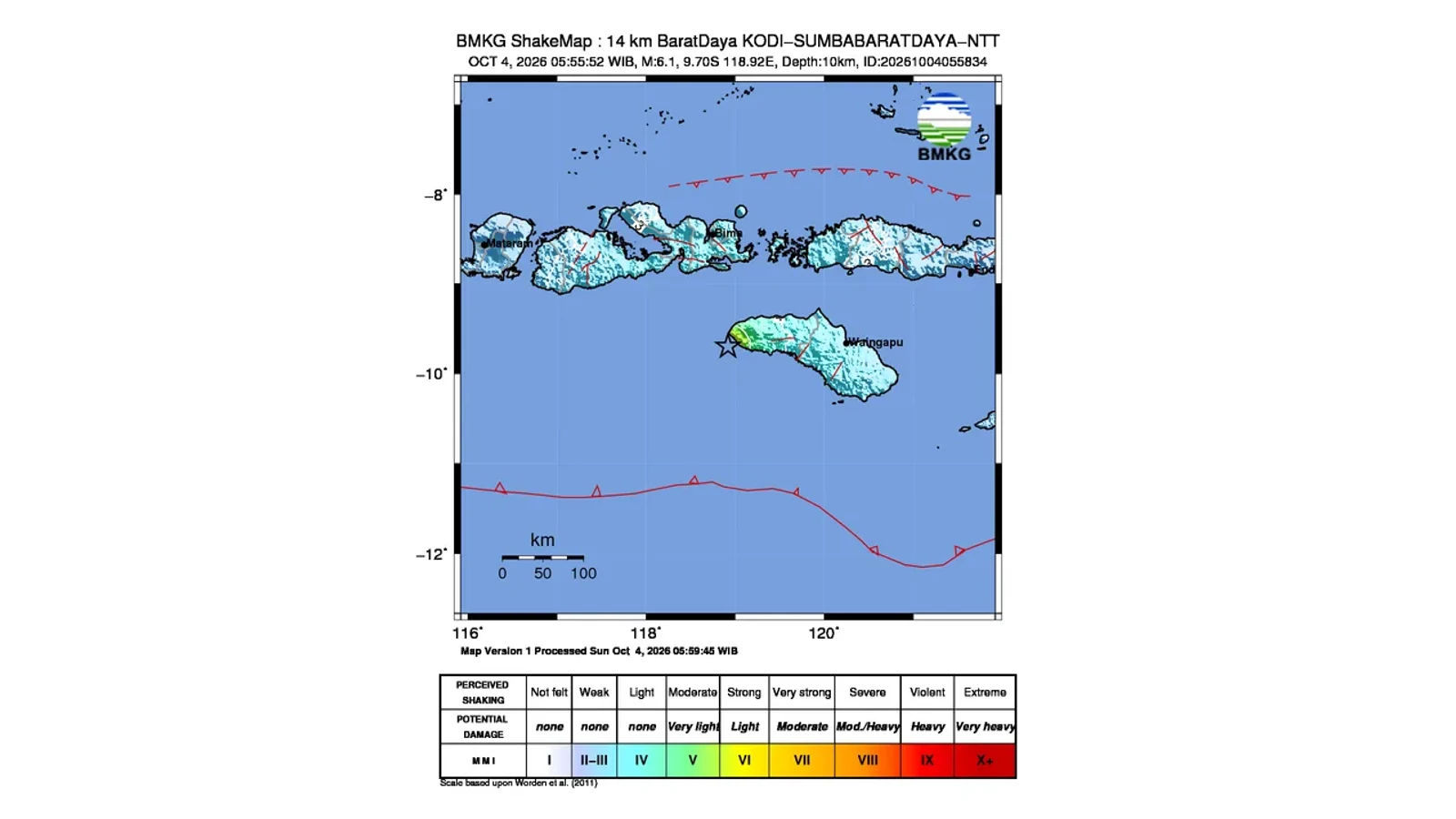
Shaking map of the Sumba earthquake, 4 October 2026. Source: BMKG.
JAKARTA, folitimes.id – The Sumba earthquake struck the southwestern coast of Southwest Sumba Regency, East Nusa Tenggara, on Sunday (4 October 2026) at 05:55:52 WIB. BMKG initially recorded a magnitude of 6.1 before updating it to M5.9 at a depth of 30 kilometres.
The epicentre was at sea, at 9.84 degrees south latitude and 118.90 degrees east longitude, or around 59 kilometres southwest of Kodi. BMKG's modelling confirmed that the earthquake posed no tsunami threat.
However, the situation did not end once the tsunami threat was ruled out. Dozens of aftershocks occurred, while reports of damage to residents' buildings and a school began arriving from Perokonda Village, Kodi District.
Data source: BMKG, Southwest Sumba earthquake information, 4 October 2026.
Waikabubak Fault Features in the Analysis of the Sumba Earthquake
BMKG classifies the Sumba earthquake as a shallow event caused by an active fault. The initial analysis suggests an association with the Waikabubak Fault, while the source mechanism indicates normal faulting.
BMKG Director of Earthquake and Tsunami Dr. Wijayanto, S.T., M.Sc., in a statement issued in Jakarta on Sunday (4 October 2026), urged the public to stay away from damaged buildings.
"Avoid buildings that have cracked or been damaged by the earthquake," read the advice in BMKG's statement signed by Wijayanto.
The warning is relevant because buildings that have lost some of their structural strength may face greater risk when further shaking occurs.
Intensity VI MMI Reaches Three Kodi Areas
BMKG's shakemap data indicate intensity VI MMI in Kodi Balaghar, Kodi Bangedo and Kodi. Tambolaka, Waikabubak, Waibakul and Raba recorded intensity IV MMI, while Bima City experienced III MMI.
Folitimes.id's review of BMKG data found that the areas with the highest intensity were around Kodi. Initial reports of damage from Perokonda Village also came from the same area.
Data source: BMKG, earthquake parameters and shakemap, 4 October 2026.
Building Damage Begins to Be Recorded in Perokonda
BMKG received information about damage to residents' buildings and a school in Perokonda Village, Kodi District, Southwest Sumba Regency. The reports remain preliminary.
Complete data on the number of damaged homes and the classification of minor, moderate or severe damage are not yet available. Folitimes.id therefore does not use the initial reports to estimate financial losses.
A Total of 62 Aftershocks Occur in Just Over Two Hours
As of 08:05 WIB, BMKG had recorded 62 aftershocks, ranging from M1.5 to M4.3.
Folitimes.id analysis: the main Sumba earthquake occurred at 05:55:52 WIB, and the aftershock update ran until 08:05 WIB. The monitoring period was around 129 minutes.
This does not mean earthquakes occurred regularly every few minutes. The calculation only shows an active sequence of aftershocks during the initial period.
No Tsunami, but the Threat Shifts to Land
BMKG confirmed that modelling showed no tsunami threat. However, the absence of a tsunami does not mean all risks have ended.
The response now focuses on inspecting buildings, recording damage, monitoring aftershocks and ensuring health facilities are ready.
False Information Can Increase Panic
BMKG urged the public to remain calm and avoid rumours that cannot be substantiated. People were also asked to ensure that information comes from BMKG's official channels.
For now, the factual focus is on three points. The main earthquake was recorded at M5.9, BMKG detected 62 aftershocks as of 08:05 WIB, and reports of damage have emerged from Perokonda.